

London, 23 March 2023.- During his visit to Brazil, Norway’s Minister of Climate and Environment, Mr. Espen Barth Eide announced that NICFI’s Satellite Data Program is extended until September 2024. After 2.5 years of the program, it has become evident that public access to high resolution satellite images leads to more effective rainforest protection, Eide said.
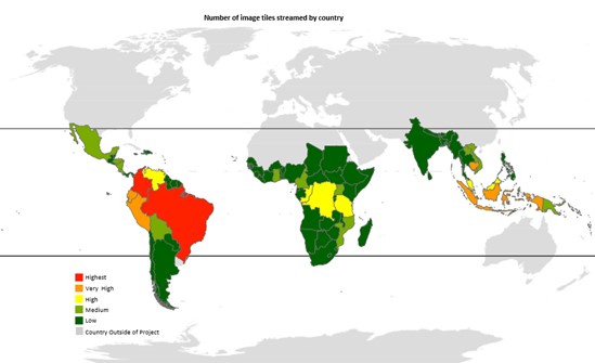
The NICFI Satellite Data Program covers all of the tropical forest regions of the world. The majority of images are streamed in key tropical forest countries such as Brazil, Colombia, Ecuador, Peru and Indonesia. Data from a total of 97 countries are used in the program. In 2020 NICFI entered into a contract with Kongsberg Satellite Services (KSAT) and its partners Airbus and Planet to provide universal access to such images.
Forest country governments are the largest user group of the NICFI satellite program. Other significant user groups are civil society, indigenous peoples, private sector, media and academia. Forest country governments are using the satellite data to discover, validate and quickly respond to changes in the forest cover, including fires. They also use the data to understand and respond to drivers of deforestation, improve planning and management, and strengthen their capacity to investigate and prosecute activities related to illegal deforestation.