Torsten Kriening
October 30, 2016
Features, Space, Space Economy News, Space for Earth News, SpaceWatch.Global Opinion
Water. We are literally made of the stuff. That’s why we can survive for weeks without food but only days without water. We drink it, cook with it, bathe in it, grow food with it, clean with it, swim in it, and use it in almost every kind of industry. After the …
Read More »
Torsten Kriening
October 23, 2016
Geopolitics News, Space Economy News, Space for Earth News, SpaceWatch.Global Opinion
With the tragedy of refugees fleeing Syria and Iraq and beyond continuing unabated, SpaceWatch Middle East contributing editor Helen Jameson writes about how satellites can, in a small way, ease the plight of those fleeing the most awful violence and desperate conditions. When did you last use your phone? Five minutes ago? An hour …
Read More »
John Sheldon
October 11, 2016
Geopolitics News, News, Space Economy News, Space for Earth News
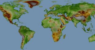
Airbus Defence and Space announced that customers can now be served with WorldDEM Digital Elevation Data for any point on Earth. Following the comprehensive global acquisition campaign and subsequent processing effort, WorldDEM data now is available for the entire World, including Antarctica and Arctic regions as well as Pacific islands. …
Read More »
John Sheldon
October 7, 2016
News, Space Economy News, Space for Earth News
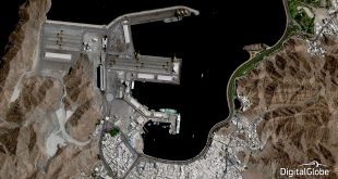
DigitalGlobe, Inc., the global leader in Earth imagery and information about our changing planet, today announced that its online Basemap Suite has reached a significant milestone, with the availability of more than 250 million square kilometers of the world’s highest-resolution 30 cm commercial satellite imagery. This includes over 500 population …
Read More »
John Sheldon
October 6, 2016
Geopolitics News, News, Space Economy News, Space for Earth News
Airbus Defence and Space has launched One Atlas, a new satellite image basemap, which covers the earth landmasses with professional grade imagery. Available online 24 hours a day, seven days a week and refreshed within a 12-month period, One Atlas provides customers with easy access to cost effective, high-quality and …
Read More »
John Sheldon
October 5, 2016
Geopolitics News, News, Space, Space Economy News, Space for Earth News
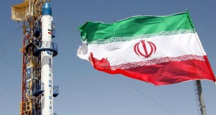
According to Iran’s Communications and Information Technology Minister Mahmoud Vaezi, satellite manufacturers from four countries have expressed interest in building Iran’s National Communication Satellite (NCS). The announcement by Minister Vaezi came after he revealed that a contract had been signed with an unnamed Russian satellite manufacturer for Tehran’s National Remote …
Read More »
John Sheldon
October 4, 2016
Events, Geopolitics News, News, Space, Space Economy News, Space for Earth News
According to Iranian and Azerbaijani press reports, Iran has signed a contract with a Russian satellite manufacturer to build a high-resolution National Remote Sensing Satellite. Iranian Communications and Information Technology Minister, Mahmoud Vaezi, told Mehr News Agency that the Iranian space programme is being developed along two parallel tracks with …
Read More »
John Sheldon
October 2, 2016
Space Economy News, Space for Earth News, SpaceWatch.Global Opinion
When you start your car in the morning or cook your dinner at night, chances are a satellite is helping you do it. We depend on fossil fuels pulled from the Earth’s crust for 82% of the energy we use. The world may not need more carbon in the air, …
Read More »
John Sheldon
September 29, 2016
Events, Geopolitics News, News, Space, Space Economy News, Space for Earth News
The Algerian Space Agency (ASAL) has announced that three Algerian satellites – Alsat-1B, Alsat-2B and Alsat-1N – have been successfully launched on 26 September 2016 by an Indian Polar Satellite Launch Vehicle (PSLV), designated PSLV C35, from the Indian Space Research Organisation’s (ISRO) Sriharikota site, known as the Satich Dahwan …
Read More »
John Sheldon
September 26, 2016
Geopolitics News, News, Space Economy News, Space for Earth News
SES S.A. has introduced a fully integrated portable surveillance and communications solution designed to provide enhanced situational awareness for border security, special event monitoring and disaster response missions around the world. Tactical Persistent Surveillance (TPS), SES’s first Government+ product offering, is a highly portable solution capable of quick global deployment …
Read More »
 SpaceWatch.Global An independent perspective on space