
The New Space sector continues to grow exponentially, and SpaceWatch.Global strives to introduce you to the sector’s brightest ideas, companies, and leaders. Torsten Kriening, SpaceWatch.Global’s co-publisher and COO, recently spoke with Thomas Gruebler, CEO of Orora Technologies.
![]() Orora Technologies is Germany’s best known, most visible New Space startup, and you are its CEO. What is Orora Tech working on now?
Orora Technologies is Germany’s best known, most visible New Space startup, and you are its CEO. What is Orora Tech working on now?
We are currently focusing on a global wildfire detection and monitoring service, based on existing satellite data and by building our own constellation of satellites. Our vision is to leverage NewSpace intelligence for a sustainable earth.
What does that mean?
 So today we provide this service based on existing satellite data, e.g. from Copernicus and other systems. These satellites deliver accurate images nearly daily, which allows us to create wonderful auto-generated maps and deliver alerts within 6-12 hours. Customer interviews have shown that effective fire management requires an average delay of no more than 30 minutes.
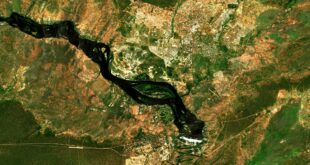
In the long term, we are developing a constellation of satellites. Actually, we started with the constellation, but focused on wildfires because climate change is causing a huge problem with wildfires today: longer dry periods, hotter summers. It’s a terrible combination. Wildfires ignite more often and everywhere. We saw this last summer in South America and more recently in Australia. The firefighters were not prepared for the fires, and they could not control them.
So, you are applying your technology to this problem: Orora Tech is building a constellation of small satellites to provide this fire detection and fire management system?
Correct. We are providing a full wildfire management system.
But aren’t there any number of Earth observation companies with huge constellations which created huge fire maps already? Didn’t it all go viral last year with the first Australian wildfires? How is your approach different?
Our technology has two huge focus points. The first is speed: Both our ground software and later space infrastructure is optimized in processing data and detecting patterns in real-time. Ground infrastructure is optimized to work data agnostic, allowing us to combine the largest number of data services available into one system. Our other focus point is fires. Not only do we want to be the first to detect fires, we are working together with partners all over the world to fully understand the fire phenomena so we can provide a complete solution to end-users who are not space experts.
We rolled out our system in a soft launch about two month ago, and we already have nearly 100 users only through word of mouth.
You say you are detecting fire events first, but you don’t have a constellation. What other sensors and sources are you using for detection?
We’re using all the accessible satellite data we can get. We use Copernicus Sentinel program data, NASA data, and data from various weather satellites. We’re now putting our own antenna on the roof to get even more data from different weather satellites. We built a huge system to acquire thermal infrared images from all kinds of sources so we can provide the best system right now.
In emergency situations like wildfires, speed is key. But some of the data sources you mention are often a few days old. How do you get the most current data to detect wildfires?
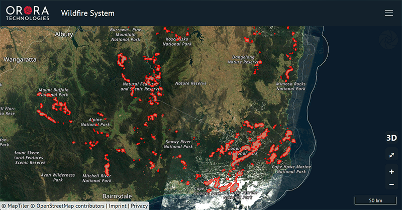
 With one single low earth orbiting satellite, you get a high resolution thermal infrared picture every 1-3 days, which is insufficient for our application. By combining data from different satellites, we bring it down to a revisit frequency of 6-12 hours. This gives us a very good overview and enables us to understand the situation in a burning area. But this still is not yet sufficient information to warrant sending a fire brigade.
Another key is resolution: GEO satellites offer a picture every 5-15 minutes, but due to their low resolution, a fire would be burning for a long time before it reaches the critical size to be detectable.
Your unique service is detecting the fire first. What does your product look like?
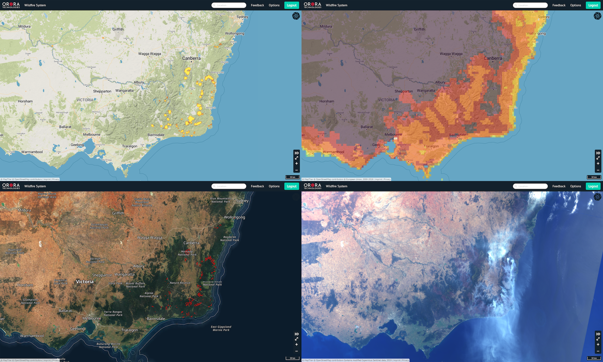
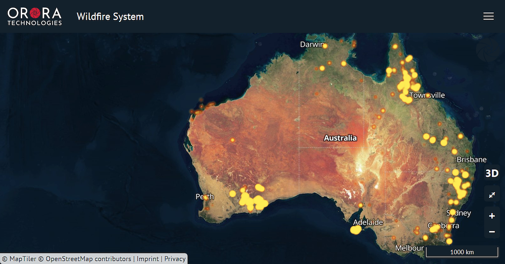
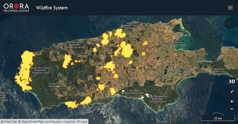
Picture a live aerial map of fires: we want to get as close as possible to this vision, and we aim to bring you closest to it. In addition to the alert feature and map of current active fires, we provide a risk map so you can see the likelihood of fire activity, and we are working on fire propagation models at the same time. In future, we will be able to tell you in which direction a certain fire is traveling. We can interpolate the fire and its position, then verify this with a second pass over the area. We also provide important data after the fire, like details about which areas have burned, etc., which can be very useful for insurance companies to verify claims.
What is your market for this product?
Our focus markets are businesses like commercial forestry and insurance, and governmental agencies or institutions.
Although the consumer market is quite small, we get inquiries every day from people who live in fire areas and want to use our solution. Paper manufacturers and commercial forestry make up most of our B2B market. Often these companies have millions of hectares of forest, as well as their own fire brigades and fire observation planes. One customer who’s been testing our system told me that he has three planes, and he flies around every day, over his property, taking pictures using WhatsApp. If he notices fire activity, he sends the photos, including locations, to his company’s fire brigade, and they take off in another plane to put out the fire. That’s quite an extreme process!
Other paper companies are fully digitalized already: they have fire watch towers every few kilometers and detect fires very quickly – but it is an expensive process. Building a constellation of satellites isn’t cost efficient for one customer in a relatively small area. However, if you can combine it for several customers, at least 10 larger paper companies, it becomes much cheaper than any tower, plane, or drone-based solution. We also did a case study on high altitude pseudo satellites (HAPS), and we discovered that to reach a similar detection speed, a HAPS solution over California is more expensive than a global nanosatellite constellation!
This brings me to the governmental market, probably one of the hardest for startups to access. Luckily, we receive great political support in Germany, and currently we receive the highest traction in Australia. Our constellation was mentioned as a possible solution to improve bushfire response by Prof. Bruce at the International Space University Adelaide Conference and in the Space & Satellite AU newspaper in February 2020.
You’ve mentioned commercial forestry, government agencies, and insurance companies. I know you also have a B2C business. Does that mean I can set my location and your system will send a warning if a wildfire is coming my way?
Yes, we can do that for you. We’ve also received many private inquiries from Australia recently, mainly around Canberra. People are reposting our fire maps via Twitter: we got huge traction from it. There’s definitely interest there, and we do not want to hide our service from people who need it, so we plan to develop a subscription-based offer for individuals soon.
What is Orora Tech’s technical status? You mentioned that your platform is ready – what about the hardware?
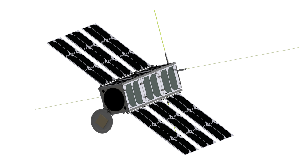 The platform is ready, and the notification system is in beta. A first version of our camera will be verified together with the image processing unit on a balloon flight this May. Our first in-orbit demonstration will happen in the first half of next year. We are one of very few companies who understand and own the IP to build a wideband, uncooled, multi-channel thermal imager enabling fire detection and temperature measurement in a single three-unit CubeSat. We will reach similar performance to the existing FireBird satellite, which is currently delivering fire maps for the German Aerospace Center to support crises all over the world, but with more than 10x less power usage, thanks to the uncooled concept.
What really makes Orora Technologies unique is that our CubeSat will process the data on-orbit with specialized AI-assisted algorithms on a space-hardened GPU. Our CubeSats will use a relay transmission to get the fire detection data down very fast. Then the information will be combined with all the other data on the ground, and our customers will get the information they need the fastest way. This unique combination is how I define NewSpace: The fluid combination of space and ground infrastructure, fully abstracted from the customers, providing information for a specific use-case directly.
What is the resolution of this imager?
By interviewing our customers, we’ve determined they are satisfied with resolution of about 200 meters. We’ve set up the best team and advisors to work on this and already applied for two patents. This resolution allows us to detect fires during their start, when they are smaller than 10m x 10m. With that resolution, you can accurately target the emergency response to the right location
Where does the knowledge for the imager system come from?
It’s not only the imager, it is the combination of all. Orora Tech is a spinoff of the Technical University of Munich. It all started in February 2015 when we developed our first satellite, the MOVE-II CubeSat. I went to a conference in London, the CubeSat symposium, very early in this project and presented our research. We were developing a distributed ADCS (attitude determination control system). At this conference, I realized that there are many startups in this market already. I also realized I did not have to make a choice between creating a startup or going into space: I could do both. That’s how the initial spark started to spin off the satellite technology, and it is where most of the team is coming from.
We also discovered very early that building nanosatellites or components for nanosatellites is not an attractive market anymore because there are so many players providing satellite buses and satellite services. Everything in this ecosystem is there already. Having worked with optics companies, I learned a lot about optics during this time, so we understood early that we could build the camera we need based on our own knowledge. We spent about a year at a university institute during the EXIST Scholarship developing the basic principles to prove our camera technology.
I’m sure the last few years have been exciting and challenging at Orora Tech. What are the biggest challenges you’ve faced?
 With all the wildfires across Europe and Australia, especially, our market seems huge. But as is often the problem, it takes time to get in contact with the governments. Also, as a startup, we’ve sometimes needed things to move quickly, and government is often the opposite of that: you send a paper inquiry, wait a month for a reply, then get an appointment another 1-2 months after that. It’s always very slow. Now our B2G sales pipeline filling up, and we see huge potential, but as a startup you need to make revenue faster. That’s why we switched to targeting commercial forestry, which has been working much better.
The other major challenge for us is finding investors. Space companies require much more financial backing than any other hardware company, but they also have the potential to grow far bigger and get larger stakes of the available market. So, our next key hire after the next financing round will be a CFO to focus on the financials.
How is Orora Tech financed currently?
Although our current finance rounds are not bringing us into space, we have attracted several strategic business angels from whom we benefit in the industry, governmental, and finance sectors.
How much money are you trying to raise?
We are targeting to raise between €2 and 5 million over the next half year. We have developed several strategic plans to use the proceeds. In addition to the in-orbit test of the hardware, we will focus further on our target markets overseas, and probably establish an entity in Australia, depending on the local developments.
How many people do you have in the company right now?
Slightly more than 20 people. We have strategic partnerships with the university, so half of our team are students, and most of them have deep experience from project work with university satellites. CubeSats are a very novel topic, so universities are nearly the only source of skilled CubeSat engineers. Our staff join Orora Tech from great projects, then do their postgraduate work at a space startup.
What can we expect from Orora Tech over the next six months?
We will do the balloon test and evaluation tests together with the TU Munich to test our camera and prove the technology. We will multiply our userbase and raise enough capital to enter crucial markets locally.
 During his studies at the Technical University of Munich (TUM), Germany, Thomas Grübler was already conducting research for two successful space projects: in the first project he launched an experiment into space on a sounding rocket, in the second he developed the hardware of a CubeSat’s Attitude Determination and Control System which is currently operated in orbit. At the same time, Thomas gained founding experience by working with several start-ups. He was selected for TUM’s Manage&More program to run an 18-month leadership and entrepreneurial program. Thomas’ enthusiasm for solving complex problems through technology led him to found Orora Technologies. Orora Tech is focusing on solving the global climate issue by providing real-time alerts for severe events, starting with wildfires. He is a sought-after presenter at industry conferences and events throughout Europe.
This interview has been edited for style and length.