By Yue Yuan
In this two-part study, exclusive to SpaceWatch.Global, researcher Yue Yuan examines the role of satellite technologies in detecting and monitoring the ongoing outbreak of the Coronavirus – also known as COVID-19 – and their wider role in national and global public health.
- Satellite Remote Sensing and Earth Observation
Satellite remote sensing is the science of identifying earth surface features and estimating their geo-biophysical properties using electromagnetic radiation as a medium of interaction from satellites,[2] with the primary goal of geographical mapping, earthquake and flood monitoring, and environment and resource surveying. In addition, remote-sensing technology could be used in epidemic prevention operations at this time to combat COVID-2019.
Satellite observation imagery not only can identify the scale and location of the source of the infection, but also plays a vital role in inspecting the landscape of temporary hospitals and healthcare infrastructure construction. Moreover, the application of remote sensing could facilitate the building of a geographic information system (GIS),[3] which is a collection of computer-based tools designed to capture, store, manipulate, manage, and visualize all types of geographical data needed for health mapping, and allow for the collective analysis of geospatial data acquired from satellites.
Case 1: Remote sensing and temporary hospital construction
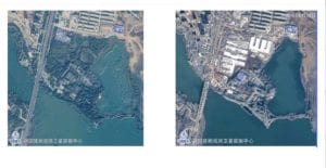
To alleviate the pressure of hospital capacity overload, two temporary hospitals, namely the “Fire God Mountain” (Huoshenshan) and the “Thunder God Mountain” (Leishenshan) with an area of 25,000 and 30,000 square meters, respectively, were built in Wuhan and each completed in 10 days. During the construction process, the Chinese GaoFen satellites, a constellation of high-resolution optical observation satellites for the civilian program of the high-definition Earth observation system (HDEOS), recorded how the hospitals were constructed from scratch at remarkable speed (see Figure 4).

The image on the left was taken on October 29, 2019, by the GaoFen-2 satellite, which delivers 0.8 meters panchromatic and 3.2 meters multispectral high-resolution satellite imagery. The proposed zone was covered by natural greenery before the hospital construction began. The second photo was transmitted to China’s Earth Observation System and Data Center on January 31, 2020. It can be clearly seen from the satellite image that the temporary hospital for the prevention of infectious diseases has already been completed.
In the meantime, other satellite sensors, including the Jilin-1 shipin-03, a commercial remote sensing satellite for high definition video; the Zhuhai-1 hyperspectral satellite; and the European Space Agency’s (ESA) Sentinel-1 satellite, perform well in aiding the evaluation of hospital construction.
Wuhan University’s key state laboratory of information engineering in surveying, mapping, and remote sensing monitored the whole design and implementation process of hospital construction by collecting and analyzing multiple satellites’ data and images. Before the project started, the laboratory deployed the Sentinel-1 satellite for Fire God Mountain Hospital’s foundation risk assessment and land subsidence measurement. By analyzing the data collected by the Sentinel-1 in the past two years based on interferometric synthetic aperture radar time series technology, the team drew the conclusion that the site revealed no sign of a spatial or linear ground surface deformation trend, and thus the land had foundation conditions sufficiently stable to support the building of the hospital.
Furthermore, using a comprehensive dataset of satellite optical imagery provided by the Zhuhai-1 hyperspectral satellite and the Jilin-1 high resolution satellite, the laboratory can obtain the water area’s surface reflectance from satellite-derived images through an atmospheric correction algorithm, to demonstrate that there is no excessive generation of sedimentation that degrades water quality near the buildings due to construction activity.
Case 2: AI-driven satellite for GIS-based health mapping
GIS plays a substantial role in facilitating the management and processing of epidemiological data and understanding the bigger picture of public health conditions by combining geospatial analysis, statistical modeling, and sophisticated algorithms. Recently, the Satellite Industry Technology Research Center at the University of Electronic Science and Technology of China developed its COVID-19 GIS-based health mapping with the support of an AI-driven satellite for infectious disease surveillance.
The AI-driven satellite, known as TFSTAR, was launched in 2018 by the university and ADASpace. Compared with traditional remote sensing satellites, AI technologies enable TFSTAR to have a more robust capability of information analysis and higher spatiotemporal resolution, performing automatic filtering and processing functions on captured images to determine what types of data should be sent back to the ground.
Combining the TFSTAR’s intelligent data processing and distribution technology, tools for semantic recognition, and a geocoding system, the COVID-19 health mapping clearly visualizes acquired satellite data with additional local features. Users not only can view the geographical distribution and trajectory of the confirmed coronavirus cases, but also are able to measure the distance between themselves and areas with intense virus infestations on the map at an administrative level.
Other functions of the health mapping include showing the available stores at which to buy disposable masks; indicating whether the user had used the same public transit facilities as the confirmed patients, based on the news released by the CDC; and locating the nearest designated infectious diseases hospital.
- Satellite Communications
Satellite communication is the most ubiquitous space-based technology, which offers extensive communication links throughout the world via diverse applications, including cell phones, radio, television, and others, which can be used during public health emergencies when land-based communication systems are down.
When a wide-ranging infectious disease outbreak occurs, it allows medical experts to perform telediagnostics and routine checkups through real-time video for people in the quarantine zones without direct contact.
In addition, the use of communication satellites can ease people’s daily life and overcome geographical barriers when interim measures against infectious disease, such as school suspension and travel restrictions, break their routines. By connecting multiusers in different physical locations through internet services, radio, television broadcasting, and text messages, people can complete remote missions from home.
Case 1: Mobile telemedicine vehicle
Telemedicine involves the use of two-way telecommunications technology, multimedia software, and computer networks when health care professionals and patients are not physically present in the same location. By scanning, collecting, transmitting, processing, and storing medical information via video and audio connections, telemedicine allows for clinical specialists to evaluate, diagnose, treat, and follow up with patients at a distance.
During the COVID-19 outbreak, mobile telemedicine vehicles have empowered a number of patients in remote areas and others unable to go to hospital by enabling them to have diagnosis of computerized tomography scans and receive remote medical consultations at home. Moreover, this technology connects the most professional expert teams with multiple local hospitals that lack sufficient staff and experience.
For instance, China Aerospace Science and Industry Corporation’s subsidiaries are providing mobile telemedicine services to hospitals in Wuhan and Shantou through satellite communication systems, which are composed of a satellite antenna, modulator, sound and video capture devices, and Internet Protocol (IP) connectivity, among other things. After collecting real-time videos and images of patients from different hospitals in diverse cities, the satellite moderator transmits and processes the acquired data to the communication satellite platform, then back to the medical control center. By doing so, experts can directly conduct remote diagnoses for infected patients and provide continuing consultation and training for local medical staff without visiting in person.
Case 2: Online education
In the face of the coronavirus epidemic, the spring semester of all students in elementary school, high school, and university has been postponed indefinitely in China. In response, the Ministry of Education is encouraging schools and educators to deliver online courses for students on a nationwide scale.
Concerning students in underprivileged rural areas who lack stable internet access, China Education Television has produced learning programs, known as “air classrooms” and suited for students from different grades, to fill the void since February. The programs are broadcast through the ChinaSat-9 satellite, operated by China Satcom, whose aim is to cover television signals in all rural places. By promoting Direct-to-Home (DTH) satellite broadcasts to rural households in China, 140 million village users are able to receive more than 48 television programs, involving CCTV news, agricultural knowledge, and entertainment shows, as well as newly added COVID-19 update news and student’s tutorial courses right now. With the help of satellite communication technology, students lacking broadband internet access don’t need to worry about being left behind anymore.
Conclusion
During abnormal public health emergencies, satellites shine.It is clear that various applications of space-based navigation and positioning systems, remote-sensing systems, and satellite communication systems have become powerful tools for assisting disease control operations during the outbreak of coronavirus in China. Innovative space technology is pitching in to combat the widespread contagious disease by enhancing patients’ engagement, improving the efficiency of disinfection, monitoring the healthcare infrastructure, broadcasting hygiene practice, and reducing exposure to the coronavirus.
As the outbreak of COVID-19 is gradually becoming a concern worldwide, no country acting alone can sufficiently protect the health of its citizens. Facing an unprecedented global health crisis, human beings share a community of common destiny. There is a need to share different countries’ disease control experience and strengthen international cooperation in the use of space technologies in accelerating the epidemic prevention process. Space technology increases our capacity, potential, and courage to fight together against global public health challenges regardless of people’s race, nationality, ethnicity, religion, or gender.
[1] UNOOSA Global Navigation Satellite Systems Education Curriculum. (2012). Retrieved from https://www.unoosa.org/pdf/icg/2013/Ed_GNSS_eBook.pdf
[2] Hay, S. I. (2000). An overview of remote sensing and geodesy for epidemiology and public health application. Retrieved from https://www.ncbi.nlm.nih.gov/pmc/articles/PMC3164799/
[3] Research Guides: Mapping and Geographic Information Systems (GIS): What is GIS? (n.d.). Retrieved from https://researchguides.library.wisc.edu/GIS

Yue Yuan is pursuing research on space security policy, China-US-Russia relations, nuclear arms control and disarmament, emerging technologies and international security. She worked with United Nations Institute for Disarmament Research’s space security department and the Center on Terrorism, Extremism, and Counterterrorism (CTEC) at Middlebury Institute. She holds a B.A. from the China Foreign Affairs University and a dual master’s degree in international affairs from the Moscow State Institute of International Relations (MGIMO) in Russia, and nonproliferation and terrorism studies from the Middlebury Institute of International Studies at Monterey in the U.S.


