SpaceWatch.Global An independent perspective on space

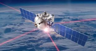
Over the last 30 years Earth Observation data (both from satellites and from aircraft) has had a fast-growing impact across a very wide range of industries from agriculture to tourism, and from peace-keeping to meteorology. The rate of development today is as fast as it has ever been, but not necessarily for the reasons one might expect. There have of course been impressive developments of new and better sensors (including advances in Synthetic Aperture Radars and Hyperspectral Sensors) which have important applications in areas such as the prediction of volcanic eruptions and mineral exploration. And there has also been an impressive growth in the number of operational Earth Observation satellites. But the biggest changes to the industry are being driven by the ability to collect, process and deliver ‘ordinary’ photographic imagery so fast and so cheaply that Earth Observation data is being ‘democratised’ and is now available to support the smallest communities anywhere in the world.

Tristram Cary, co- founder and Chairman of a new company called GeoXphere, has been closely involved in the Earth Observation industry for over 25 years, and his experience of both satellite and aircraft-based Earth Observation gives him an excellent perspective on the whole industry. A former naval officer turned military engineer, Cary moved into EO when he became the Technical and then Marketing Director for the UK National Remote Sensing Centre (NRSC) in the mid 1990s. He joined shortly after Margaret Thatcher’s government had privatised NRSC to develop commercial applications for satellite EO data which had, until then, been used mostly for scientific applications such as ocean monitoring and atmospheric research. While he was at NRSC in the 1990s there was a general assumption in the industry that satellite-based EO would replace aircraft-based EO as satellite data became higher resolution and as the number of satellites grew. But Cary was always convinced that satellite and aircraft-based EO were complementary markets and that both would grow in tandem. Satellites cannot ever match the capability of an aircraft to capture high resolution data, 3D data or to capture data exactly when it’s needed (for example flying under the cloud base to measure flood damage at the height of a storm). In 1998 Cary left NRSC to found Getmapping, a dotcom start-up which created the first ever commercial aerial photographic survey of a whole country (Great Britain). Getmapping’s photography was sold to any industry or individual via the Internet, and the company was a precursor to Google Earth which was launched in 2003. Getmapping remains the UK’s leading supplier of aerial photography and data hosting solutions. Getmapping also owns Geosense, a leading aerial survey company in South Africa.
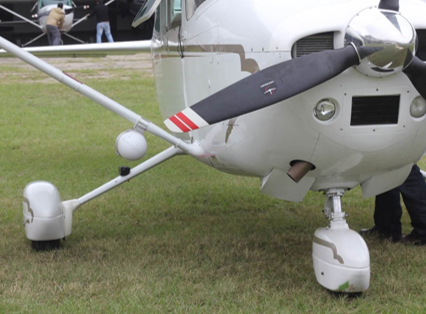
Getmapping’s first aerial survey of Britain used specialist large-format film cameras. The 130,000 negatives had to be scanned and then ‘orthorectified’ into a seamless map-accurate mosaic by a team of about 300 staff using software which is archaic by today’s standards. In 2004 Getmapping became a pioneer of Vexcel’s new digital aerial survey cameras, and the company has remained a user of top-of-the-range large-format aerial cameras ever since. “Getmapping is involved in large scale photography for which you need big cameras that cost around $1m, weigh about 70 kg and must be fitted into a dedicated survey aircraft with a camera hole” explains Cary. “But these aircraft/camera systems impose a severe limitation on the flexibility of a survey company to undertake projects in remote locations. For instance, Geosense operates a large-format camera system in South Africa which is ideal for surveying large metropolitan areas like Cape Town and Johannesburg. But it is not economical to send the aircraft/camera system to survey a small township 2000 miles away in say Angola or Mozambique, because the transit costs and the challenges of arranging air traffic control and customs clearance makes the job unaffordable. The same argument applies even in the UK. The costs of transit from Getmapping’s operational base at Oxford airport makes it uneconomical to conduct a survey of say a small town in Scotland”. For this reason Cary has spent years watching the evolution of a new generation of small cameras that can be fitted externally onto any small aircraft. “Such a camera would revolutionise the aerial survey industry because it would allow you to hand-carry the camera anywhere in the world and fit it to a local aircraft – at a stroke surveys of small remote communities would become affordable.” In 2015 Cary found the perfect camera system from a small U.S.-based company called WaldoAir. “This was the system we had been looking for. The XCAM is a high-quality system which weighs about 3kg (compared to 70kg for a top-end Vexcel) and costs around $50,000 (compared to about $1million for a large-format Vexcel system with the associated gyro-stabilised platforms etc). The XCAM has no export restrictions and can be carried as hand luggage anywhere in the world. The XCAM has CAA and FAA clearance to be fitted to any single-engine Cessna, and the fitting process takes no more than 20 minutes. Of course the XCAM does not have the ability to cover such large areas as the Vexcel systems, but it competes well over areas up to several hundred square kilometres, and, critically, the quality of the data is roughly comparable. There are also several variants of the XCAM which provide RGB, Near Infrared and Thermal data, so the system is highly versatile.”
“At the other end of the scale, XCAM collects data much more cost-effectively than a drone system which is limited to line-of-sight operations and which cannot operate over a populated area. We have found that XCAM flown on a Cessna 172 can collect agricultural data in the USA at about 25% of the cost of a drone, and we recently completed a project to map 103 quarries in Spain which took us three days compared to a drone operation which would have taken 10 days. In summary, XCAM addresses the sweet spot between drones (which are cost-effective for areas of a few acres) and large -format cameras (which are cost-effective for areas over about 1000 sq kms).”
To make the best use of the XCAM system, Getmapping and WaldoAir formed a joint venture company, with Cary as the Chairman. GeoXphere has combined the XCAM survey cameras with Getmapping’s web-based data-delivery and GIS software to offer end-to-end survey services to customers and partners all over the world. XCAM systems are already being used being used successfully in every continent in the world except Antarctica.
GeoXphere is establishing an international network of market partners who are helping to develop the global market for XCAM services. GeoXphere partners lease the XCAM systems for an initial fee of $10,000 followed by a monthly payment of about $2,000 (depending on the XCAM model) which pays for maintenance and support, and contributes towards an updated camera system after a few years. Cary explains “Our leasing model is designed to minimise the cost of entry for XCAM partners and to ensure that they are always using an up-to-date camera system. We already have lease partners working in the USA, Kenya, South Africa, the UK and the Philippines, with several more companies evaluating the technology. In addition, we are investigating the Overseas Development and Conservation markets with organisations such as King’s College, London, because we think that the portability of the XCAM system makes it ideally suited for the small-scale mapping and cadastral work which is at the heart of so many projects in the developing world – these countries are often relying on maps which have not been updated for decades, and it makes it impossible for them to undertake basic functions such as tax collection.”
The Quality of XCAM compared to other high-end camera systems
A major challenge facing GeoXphere is to explain how a small camera like the XCAM (3kg and $50,000) and can compete with a camera system like a Vexcel (70kg and c $1m including the IMU and gyro-stabilised mount). There are several answers to this question, as Cary explains:
1.The focus has shifted from the camera to the image processing
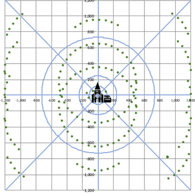
“Up until about 2014 the creation of an accurate orthorectified mosaic depended on having a very expensive camera and lens system as well as a very expensive Inertial Measurement Unit (IMU) which would record the exact position and orientation of the camera as each frame was exposed. But in recent years there has been a revolution in the power of photogrammetric processing software which now uses pattern-recognition algorithms to find literally thousands of matching points between overlapping images. The photogrammetric software then works ‘backwards’ from the matching pairs to find a unique solution for the exact position and orientation of the camera (x/y/z and roll/pitch/yaw) as each photograph was taken. This means that the accuracy of the resulting survey is no longer dependent on the estimation of the position of the camera as measured by the camera system itself. Instead the accuracy of the survey is driven by the processing software. GeoXphere has conducted an extensive trial of the accuracy of an XCAM survey using a calibrated range in Arizona which shows that the XCAM achieves sub-pixel absolute accuracy in a survey area of 10 sq kms using just five Ground Control Points (GCPs) across the whole block. This accuracy is comparable to the most expensive camera systems on the market.”
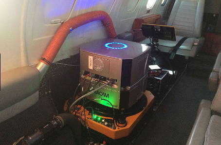
“We can use any photogrammetric software to process XCAM data, but we prefer to use Skyline software, and we support or partners in using Skyline if necessary. Skyline has two great advantages over other systems. First it produces much more accurate edges in its 3D models than other systems. Second it breaks a project area up into independent sub-areas which can all be processed in parallel. This allows a survey area to be processed in a very short time compared to other systems, using multiple processors hired by the hour in the cloud if necessary to speed things up.”
2.Circular-flight path
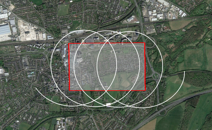
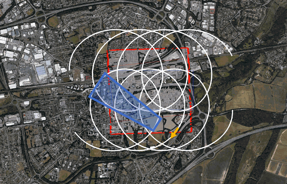
“The second reason for the exceptional quality of XCAM surveys is that we have developed a ‘patent-pending’ circular flight path to capture XCAM data which is especially useful for 3D City modelling. The plane flies an advancing circle pattern (guided by a special WaldoAir Flight Control System) and the camera is tilted so that it points at an oblique angle towards the centre of the circle. This means that every building in an urban area is viewed by the camera from over 100 positions from every azimuth angle and inclination to the vertical which results in a 3D City Model of exceptional quality.”
The Skyline President, Bob Peters, confirms that “XCAM is the price-for-performance leader in mapping cameras. We get fantastic 3D results from the combination of the XCAM and their patented circular flight pattern.”
3. Commercial camera technology has caught up with the specialist camera makers
The third reason for the exceptional quality of XCAM surveys is the rapid improvement of standard commercial cameras. As Cary explains: “up until about 2000 there was an enormous difference in the quality of the lenses and CCDs of commercial ‘off-the-shelf’ and specialist ‘photogrammetric’ cameras. But this gap has been closing fast and high-end commercial cameras such as the Cannon system used in the XCAM have excellent lenses and CCDs which are very nearly as good as specialist cameras which cost many times as much.”
4. Beware over-specification!
Finally, Cary warns that is vital to make sure that the specification for a survey is appropriate for the task. He explains “it is very common for a customer to ask for a pixel resolution and an absolute accuracy for a survey which are well beyond what is really required for the task. Sometimes customers also specify a high-end photogrammetric camera system without any idea of why they think it is necessary. I am absolutely confident that the XCAM system is fit-for-purpose for very nearly every survey requirement. We just need to educate the customer to understand that high quality surveys no longer need the expensive dedicated systems that were necessary ten years ago.”
Aerial versus Satellite Earth Observation
So, does GeoXphere view itself as a rival to satellite Earth Observation? Cary says that both systems have their place and that they work in a complementary way.
“Satellites have global coverage and between them they can re-visit every inch of the globe on a more or less daily basis, and in safety. So they are ideally suited to tasks such as monitoring the thickness of the Antarctic ice cap, mapping illegal logging in Borneo and monitoring the movement of civilian populations fleeing from a war zone. But satellites are restricted to resolutions of about 50 cm at best and they cannot collect oblique data for 3D modelling or collect data under the cloud base for a time critical survey such as flood damage assessment. Satellite data can also be very expensive especially if you need to programme the satellite to collect data of a particular area.”
“So it’s clear that satellite surveys and aerial surveys should exist side by side and that a customer should use the best system for each particular task. It’s a worry that quite often a national aid agency will insist on using satellite data for a task even though an aerial survey would be more cost-effective. I think this is often done to help to justify the huge public expense of launching and maintaining an Earth Observation satellite programme.”
3D City Data and Smart Cities
XCAM is addressing a wide range of markets all over the world including Agriculture (crop monitoring), Transport (surveys for railway lines and roads), Utilities (monitoring pipelines and power cables), and Mines (monitoring stockpiles and mine infrastructure).
But the main and fastest growing market is urban mapping for local government, and in particular the development of high quality City 3D models for Smart City programms. Smart City applications include the modelling of 5G ‘line of sight’ aerial networks, the development of high quality 3D maps for driverless cars, utilities management and a host of 3D location-based services. 3D City models are essential for Smart City applications, and XCAM technology offers high quality 3D data at a fraction of price of other systems.
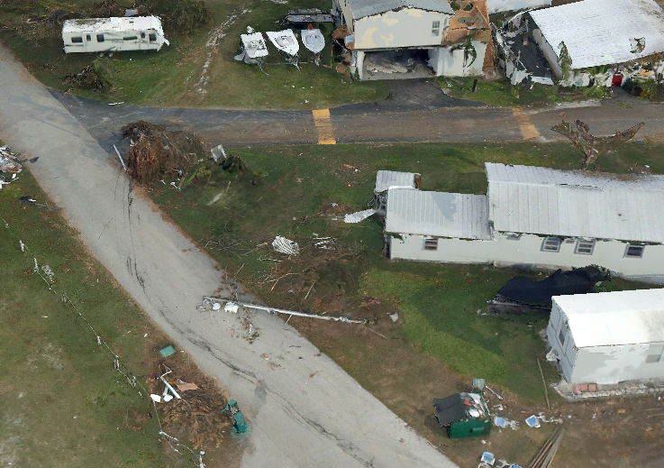
Hurricane Irma
To end this article, here is an example of the versatility of XCAM technology, which is also an illustration of an application beyond the reach of satellites. In the immediate aftermath of Hurricane Irma, 8 XCAM cameras were assembled at a few days’ notice to help Comcast Corporation to analyse damaged cables in Florida. Comcast were delighted with the quality of the imagery. James Summerville, CEO of WaldoAir, explains “we decided to fly this survey at 2cm resolution so that damaged cables could be clearly seen. The data was flown under the cloud base in very testing wind and light conditions just a few hours after the hurricane passed through. Furthermore, we were able to process all the imagery using Skyline within a day so that Comcast could get on with the repair work without delay. All eight XCAM systems worked perfectly which is a testament to the robustness of our technology.”
We would like to thank Tristram Cary very much for his time, and if this article has piqued your curiosity in GeoXphere, visit the website at www.geoxphere.com
Original published at: https://spacewatch.global/2017/10/spacewatchme-oped-tristram-cary-of-geoxphere-taking-a-different-perspective/