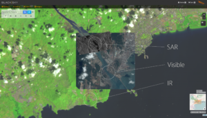
Spaceflight Industries revealed on April 5, 2017, BlackSky Spectra, its on-demand satellite imagery service which enables customers to discover archive images and task new images from 13 high-resolution imaging spacecraft, all from one convenient web platform. BlackSky Spectra enables customers to easily look at the planet across every spectrum, from visual imagery to multi-spectral data including synthetic aperture radar (SAR), hyperspectral data, and radio frequency detection, which provides a more comprehensive view of the changing world.
“BlackSky is transforming how we look at the world by integrating the widest variety of sensors into a revolutionary, easy to use service,” said Jason Andrews, CEO of Spaceflight Industries. “Increasing our capacity to take images and expanding the data set enables organizations to understand our changing world like never before.”
In addition, the company announced Airbus’s Pléiades, SPOT6/7, KazEOSat-1, and TerraSAR-X are the latest sensors to join the BlackSky network. Other spacecraft include 21AT’s TripleSat, SIIS’s KOMPSAT2/3/3A/5, and UrtheCast’s Deimos-2. Together, this ecosystem represents the largest network of high-resolution sensors accessible from an online catalog. Users can also directly task these satellites by selecting a specific location on a map and indicating how often they want a picture taken.
Other sensing modalities such as radar can help supplement visible satellite imagery, especially in areas with cloud cover or after dark. For example, a humanitarian agency can use BlackSky Spectra to find and purchase historical images of an island where a typhoon recently hit to locate transportation hubs and centers of population. If the storm’s cloud cover obstructs the view, the agency has the option of purchasing additional radar imagery to best determine where relief aid should be delivered.
The addition of Airbus sensors to BlackSky Spectra significantly increases the high-resolution tasking capacity and archive content available to users. Airbus’s Pléiades satellites provide responsive 0.5-meter imagery product, while its SPOT duo provides extensive coverage at 1.5-meter resolution. TerraSAR-X delivers a diverse set of SAR products supporting a wide set of use cases. Through Airbus, users can also access KGS’s KazEOSat-1, which provides 1-meter imagery.
“Historically, satellite imaging has been difficult to obtain, therefore limiting its use,” added Andrews. “BlackSky’s mission is to change that by creating an easy-to-use online service.”
In addition to remote sensing products, BlackSky provides a variety of real-time data feeds and monitoring services that drive value-added insights. Organizations are able to download imagery from the online catalog which features more than 25 million images. By 2020, BlackSky will complete its 60-satellite constellation, which will offer 1-meter images of anywhere on Earth in near real time. Early adopters of the platform range from international financial institutions and government organizations to entrepreneurial analytical firms.
About Spaceflight Industries:
Spaceflight Industries is enabling timely and affordable access to space while redefining how we observe our world in real time. Through its services Spaceflight and BlackSky, the company offers innovative satellite design, rideshare launch management, global communications networking, and a geospatial intelligence service to support a new era of global awareness. Founded in 1999, the Seattle-based company has a well-earned track record of success on a global scale.
Original published at: https://www.spacewatchme.com/2017/04/u-s-company-spaceflight-industries-launches-blacksky-spectra-satellite-imagery-service
 SpaceWatch.Global An independent perspective on space

