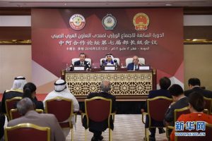
China and the League of Arab States (LAS) agreed to promote the use of China’s BeiDou global navigation satellite system (GNSS) at the 7th Ministerial Meeting of the China-Arab States Cooperation Forum held in Doha, Qatar, on 16 May 2016.
The BeiDou system is a rival to the US Global Positioning System (GPS), Russia’s GLONASS, and Europe’s Galileo. At present BeiDou consists of 20 satellites in both medium-earth and geostationary orbits, and aims to have a total of 30 satellites providing global GNSS coverage by 2020.
The priority for Chinese policy makers and satellite engineers is to make the current constellation available to countries involved in China’s ambitious ‘One Road, One Belt’ initiative that aims to revive the ancient land and maritime trade routes that connected Europe and the Middle East with China, known as the Silk Road.
Most countries in the Middle East have committed themselves to involvement in the One Belt, One Road initiative, and many are also members of the recently created Asian Infrastructure Investment Bank (AIIB) that will fund many of the infrastructure projects that will be built across Eurasia in the coming years. These infrastructure projects include major port upgrades across the Indian Ocean, and rail and road links from China through Central Asia and the Middle East through to Africa and Europe. BeiDou GNSS is seen as vital to aiding the operations and maintenance of these Indian Ocean and Eurasian links.
The Ministerial Meeting of the China-Arab States Cooperation Forum agreed to set up formal cooperation mechanisms to promote BeiDou GNSS use across the Middle East. The main mechanism for this will be the creation of a China-Arab States BeiDou Cooperation Forum, the first of which shall be held next year. This forum will promote the use of BeiDou GNSS in the Arab oil and gas sector, agriculture, and traffic and urban management.
Ran Chengqi, Director of the China Satellite Navigation Office said of future Chinese-Arab BeiDou GNSS cooperation, “We will open cooperation with them in terms of technological exchanges, personnel training and promotion of BeiDou-based applications. The countries involved have expressed an interest in the use of our satellite navigation services.”
During the China-Arab States Cooperation Forum in Doha, Qatar, Chinese engineers held a BeiDou GNSS demonstration where they revealed that local BeiDou receivers could receive signals from up to eight BeiDou satellites, making the system just as accurate and reliable as any other operational GNSS system in the Middle East.
 SpaceWatch.Global An independent perspective on space

