At GEOINT 2026 in Aurora, Colorado, Torsten Kriening spoke with Thomas Gruebler of OroraTech US during the company’s first appearance at the conference.
Coming from the wildfire sector, Gruebler arrived expecting conversations around satellite imagery and monitoring. What stood out instead was how deeply AI has already been integrated into operational workflows across the intelligence and defense community.

Not as a future concept.
As normal practice.
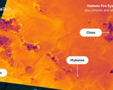
AI-generated reports, clearly marked as such, are already being used in briefing environments. Meanwhile, many teams in wildfire operations still rely on manually written daily situation reports, despite already using advanced modeling tools elsewhere in their processes.
For Gruebler, the more important shift is not image analysis itself, but the growing use of agentic workflows capable of combining far more data streams than humans can realistically process alone.
The attraction is speed.
The tradeoff is trust.
That tension appeared repeatedly across GEOINT 2026. Faster analysis, broader data integration, and more automation are becoming standard expectations, even as questions around verification and oversight remain unresolved.
Another surprise for Gruebler was the openness of the show floor. Despite the strong government and defense presence, many companies were unusually direct about what they are building and how it works. Conversations moved quickly from demonstrations into potential collaboration, particularly around maritime monitoring and infrastructure protection.
The atmosphere felt less guarded than expected.
More practical.
For OroraTech, the conference was less about showcasing wildfire detection and more about understanding where those capabilities fit into a much larger operational ecosystem.
And how quickly that ecosystem is evolving.