Ibadan, 28 May 2026. – EarthDaily and Geospatial Intelligence Pty Ltd have entered a new partnership to expand access to science-grade Earth observation data and analytics for customers across Australia.
Through this partnership, Australian customers will gain local access to EarthDaily’s calibrated Earth observation data and analytics, supported by Geospatial Intelligence’s experience serving government and industry across Australia.

The partnership combines Geospatial Intelligence’s understanding of the Australian market and expertise in government-focused solutions with EarthDaily’s next-generation Earth observation constellation and change detection capabilities. Together, the companies will support Australian organizations seeking timely, reliable Earth observation intelligence for operational planning, monitoring, and decision-making.
Australian customers will subsequently benefit from:
- Consistent, daily 5-meter imagery designed to support monitoring and operational planning across Australia and the broader Indo-Pacific region;
- AI-ready Earth observation data structured for integration into advanced analytics and decision-support workflows; and
- Local support from Geospatial Intelligence’s Canberra-based team, with experience delivering geospatial solutions for government and mission-focused customers
Geospatial Intelligence’s strong presence in Canberra reinforces the city’s standing as a national hub for geospatial intelligence. Furthermore, the company’s local market understanding and strengths in high-resolution satellite imaging and domain-specific geospatial solutions align closely with EarthDaily’s mission to deliver consistent, calibrated Earth observation data for operational use.
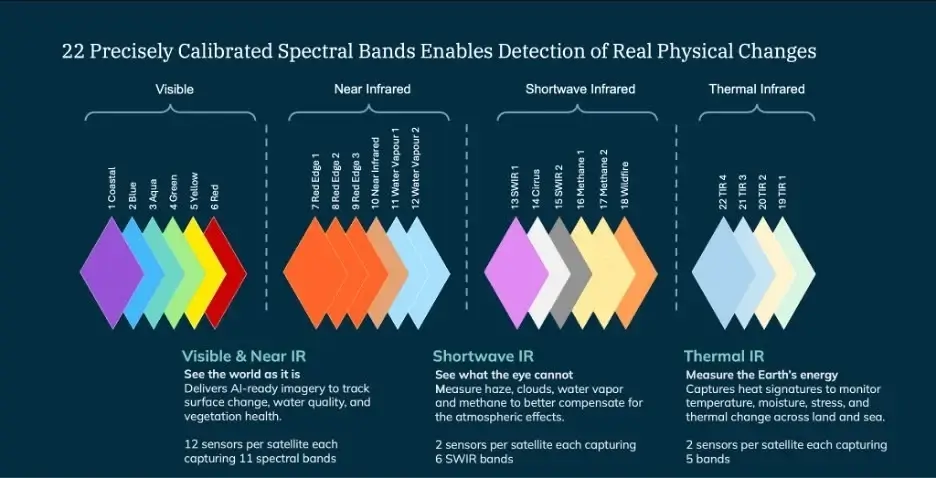
Likewise, the EarthDaily Constellation offers daily, global, multispectral imagery at 5-meter resolution across 22 spectral bands, spanning visible, near-infrared, shortwave infrared, and thermal infrared wavelengths. Built for consistency across time, geography, and sensors, EarthDaily’s data is intended to support reliable monitoring, time-series analysis, and AI-driven workflows at scale.
With EarthDaily moving toward commercial operations in the second half of 2026, and seven satellites now in orbit, the partnership gives Australian organizations a trusted local channel to access EarthDaily’s science-grade data and change detection capabilities through Geospatial Intelligence.