

Finnish New Space leader ICEYE unveiled its newest in-orbit satellite demonstration, the capability to create synthetic-aperture radar (SAR) videos from the company’s current SAR satellite constellation, during Satellite 2020 in Washington, DC. ICEYE’s innovative imaging and processing technique for generating SAR videos can be used for advanced analysis of movement from a single satellite pass. This in-orbit demonstration opens new use cases for data users, while validating once more the forerunner status of ICEYE in SAR satellite technology.
Generating SAR video data from ICEYE SAR satellites is done by initially focusing imaging on a single precise location for 20 seconds or more during an individual satellite pass. The acquired data is then processed into several high-resolution frames from that period, rather than into a single image. ICEYE has developed the techniques involved by utilizing its own satellite hardware and processing software.
“The capability to generate SAR videos from a single satellite pass is an exciting feature for advanced radar image analysis of movement,” said Pekka Laurila, CSO & Co-founder, ICEYE. “We’re proud to be delivering significant amounts of standardized SAR data from orbit right now, and a big part of our commitment to our global clients is to continue to develop new capabilities that they can benefit from.”
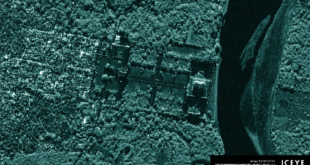
As a technical demonstration of the new capability, ICEYE published a collection of several ICEYE SAR video acquisitions, featuring a port in Busan, the Heathrow Airport, Las Vegas, the Bingham Canyon mine, and Tokyo. Locations are listed in the order of appearance. In these SAR videos, movement can be detected in the form of a vessel maneuvering near a port, airplanes moving at an airport, and trucks moving along a road. In addition, the videos show how large buildings in cities reflect radio waves from different imaging angles, as the satellite passes over the area.
“SAR video data is helpful in guiding analysts to moving objects for deeper technical analysis. The video previews that ICEYE creates from the acquired data are helpful for visually communicating analytical results – forming a more complete suite of tools for the analysts and decision makers.”, said Dr. Mark Matossian, CEO of the US subsidiary of ICEYE. “The market for advanced image analysis continues to grow, as new capabilities are introduced – along with new satellite units. With roughly 20% of the world’s commercial SAR satellite units in orbit right now, ICEYE has shown to be in its own league in swift SAR satellite development.”
This announcement was released on 9 March 2020.