Credit: © DLR
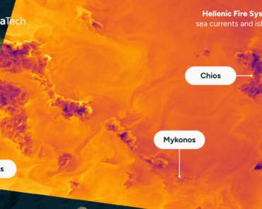
London, 12 June 2025 – The German Aerospace Center (DLR) has launched a new initiative to harness satellite data for enhanced wildfire detection, analysis, and response coordination, using satellite data has been licensed by DLR to Munich-based Earth observation company OroraTech. Announced this week, the program brings together scientific expertise, remote sensing technology, and government collaboration to address the escalating threat of wildfires driven by climate change across Europe and beyond.
As part of the initiative, DLR is developing and deploying space-based tools that integrate satellite imagery, thermal sensors, and AI-driven analytics to detect ignition points, track fire progression, and assess damage in near real-time, integrated into OroraTech’s Wildfire Solution platform. The initiative supports the German federal government and civil protection agencies, as well as European partners, by improving situational awareness and supporting faster, more coordinated emergency responses.
From Observation to Intervention: Strengthening Europe’s Climate Adaptation Tools

The timing is crucial. Europe has experienced a marked rise in the frequency and severity of wildfires, particularly in the Mediterranean and Central European regions. With conventional monitoring systems struggling to deliver timely, wide-area coverage, the integration of space-based observation is becoming a strategic necessity for climate adaptation, disaster resilience, and environmental security.
DLR’s wildfire monitoring capabilities leverage satellite assets such as Sentinel-2 (via the EU Copernicus programme), the German EnMAP mission, and its FireBIRD constellation, which specializes in high-temperature event detection. These technologies provide a dual-use advantage, offering both civilian protection and potential applications in defense-related environmental intelligence.
Strategic Context: Space as a Public Safety Infrastructure
This development reflects the growing shift toward space systems as core components of public safety infrastructure. In a context of increasing climate volatility, the fusion of Earth observation and AI enhances Europe’s capacity for autonomous disaster response—reducing reliance on third-party platforms and reinforcing space sovereignty within the EU.
The initiative aligns with EU priorities under the Green Deal and the European Space Programme, including plans to expand the Copernicus Emergency Management Service (CEMS). It also illustrates how institutions like DLR are contributing not just to scientific research but to operational resilience, making EO data actionable for frontline responders.
As fire seasons lengthen and resource pressures mount, DLR’s work underscores the strategic role of satellite data in safeguarding both ecosystems and communities—offering a model of how science, space, and civil protection can converge to meet one of the defining challenges of our time.