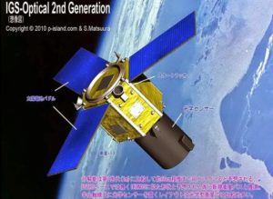
Japanese satellite and space industry giant Mitsubishi Heavy Industries (MHI) has announced that an MHI H-IIA satellite launch vehicle will send Japan’s eighth Intelligence Gathering System (IGS) reconnaissance satellite into orbit from the Tanegashima Space Centre in Kagoshima Prefecture, southwest Japan, on 27 January 2020.
The IGS satellite will carry an electro-optical camera and will join seven other IGS satellites already in orbit. Japan currently operates five high-resolution synthetic aperture radar (SAR) imaging and two electro-optical IGS satellites that monitor military activities by North Korea and China, to include ballistic missile and nuclear weapons tests, naval activities in the South China Sea, East China Sea, the Sea of Japan, and the Western Pacific Ocean.
Japan also uses the IGS satellites to monitor Russian military activities given Tokyo’s longstanding territorial dispute with Moscow over the Kuril Islands, also known as the Northern Territories, to the north of Japan and off the coast of Russia’s Far East.
More recently, both China and Russia have conducted naval and aerial maneuvers in Japanese territorial waters and airspace in order to test Japanese defences and responses. Japan is also deeply concerned about North Korean ballistic missile tests and its nuclear weapons programme, given the hostility of Pyongyang towards Tokyo and their geographical proximity.
As a result, IGS satellites provide Tokyo with strategic early warning of North Korean, Chinese, and Russian activities, as well as a useful defence diplomacy tool for sharing its intelligence with allies such as the United States in return for American intelligence Japan might find otherwise more difficult to obtain.
The Japanese government intends to put ten IGS satellites in orbit at any one time, consisting of a mix of electro-optical and synthetic aperture radar sensors to assure day and night, all-weather, coverage of targets of interest with regular revisit rates. IGS imagery is supplemented by Japanese civil Earth observation satellites such as the ASNARO system, as well as commercial and allied imagery.


