Written by Peter Round, Head of Europe and Global Vice President, Business Development – Defence & Intelligence at EarthDaily

Wide-area, daily global revisit is now technically achievable. The implications extend well beyond collection. At that scale and volume, manual review cannot keep pace, automation becomes structural, and data governance carries strategic weight.

The geospatial intelligence (GEOINT) landscape is being reshaped by the rapid growth of commercially available data and by significant advances in analytical capability. Commercial systems now sit alongside national assets as credible components of the intelligence picture. A broader supplier base increases resilience and flexibility across allied and coalition environments. These developments are unfolding amid geopolitical tensions and more frequent extreme weather and climate disasters. Infrastructure is under strain and operational timelines are tightening. In this environment, control over geospatial data assumes greater strategic importance, and sovereign authority is increasingly concerned with how information is stored, processed, and governed.
Persistent collection produces insight, but it also carries responsibility. Data must be filtered, managed, and applied in time to shape decisions that matter.
Automation in an Era of Continuous Collection
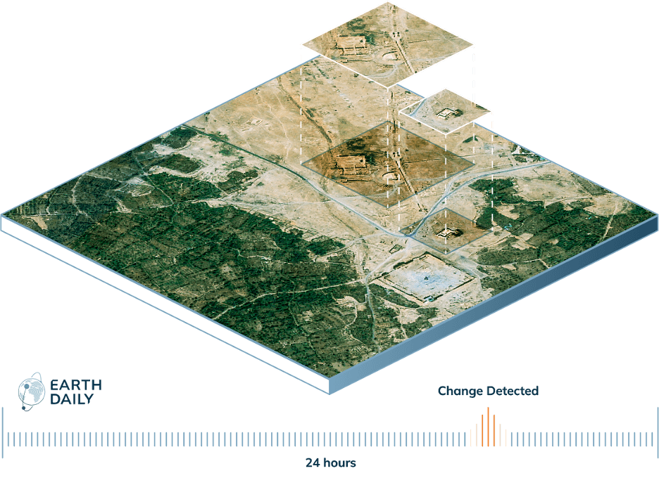
The scale of daily collection fundamentally alters how GEOINT must be handled. When imagery is collected continuously and at global scale, traditional, analytic models struggle to keep pace. Teams reviewing imagery manually cannot keep pace with the flood of data that updates every day across wide areas. This volume requires systems that operate without humans-in-the-loop at the point of first detection.
Sophisticated artificial intelligence (AI) and machine learning sit at the center of modern GEOINT workflows. Automated change detection monitors activity over time and identifies where something has shifted. The first layer of screening happens automatically, allowing analysts to concentrate on interpretation and decision support.
Wide-area collection paired with automated processing makes persistent coverage data usable. It becomes possible to look everywhere repeatedly and identify emerging activity early. Once change is detected, it can be assessed in context and directed toward further collection or operational response.
Automation also impacts who can work with GEOINT. Initial processing depends less on large teams working through raw imagery. Tools increasingly allow users to query data directly, including through simplified and, in some cases, plain-language inputs. Expertise is still needed for interpretation and judgment. However, routine detection tasks depend less on intensive manual screening.
Persistence and the Earliest Moment of Change
The value of automation is magnified when paired with persistence. Returning to the same location daily allows change to be identified from the moment it begins. Early activity, whether the cutting of a road through forest, the expansion of a construction site, or emerging stress on infrastructure, becomes visible while there is still decision space. Intent can be assessed, further collection directed, and mitigation considered before escalation.
Persistence also creates continuity. Daily collection builds a documented and uninterrupted record. When an unexpected event occurs, the progression leading to it can be examined. Infrastructure degradation, environmental stress, or severe weather impact can be traced across time. That visibility supports more informed planning and sharper risk assessment. In crisis situations, rapid analysis of affected areas helps direct response and recovery efforts. Daily revisit reshapes timing, improving early awareness and reinforcing accountability.
Accessibility and the Democratization of GEOINT
Automation and persistent coverage are expanding participation in GEOINT. Wide-area collection combined with automated analytics reduces reliance on large, specialist teams because much of the initial screening and pattern recognition now happens automatically. Datasets no longer require frame-by-frame review before meaningful signals emerge. Information can be queried through simplified tools and, in some cases, plain-language inputs. Initial processing depends less on deep technical expertise at every stage. As a result, space-based intelligence becomes usable without building extensive analytic structures from the outset.
The geospatial landscape is becoming more open and capability can develop incrementally to ultimately align with national priorities and resources. Access to space-based data can move beyond a narrow circle of major powers with established technical infrastructure.
Sovereignty in a Changing Geopolitical Environment
Geospatial intelligence is fast-evolving within a more contested geopolitical environment. With national governments placing greater emphasis on independence in access to geospatial data and control, sovereignty is at the data layer.
Sovereignty concerns where data is held, who processes it, and who makes decisions about its use. The ability to host data within national or regional cloud infrastructure keeps sensitive information within domestic jurisdiction and governance frameworks. For small and medium nations, this matters. Greater control over data reduces reliance on external partners for critical geospatial insight and allows capability to develop in alignment with national priorities.
These concerns intersect with geopolitical tensions, climate volatility, and infrastructure stress. Persistent, locally governed GEOINT strengthens early warning, monitoring, and recovery efforts, with direct implications for security and resilience.
Designing for the New GEOINT Environment
Automation, persistence, accessibility, and sovereignty shape how geospatial systems are structured in practice. Constellations must be designed with those conditions in mind. The aim is straightforward: look everywhere, every day, with calibrated consistency. Coverage can be integrated with AI-driven change detection, surfacing activity across large areas and allowing analysts to concentrate on interpretation, context, and action.

Consistent collection also creates continuity creating records that can inform anticipation and supports more targeted response and recovery.
Embedded accessibility and sovereign control lead to automated analytics, reducing technical overhead and offering data that can be hosted within regional cloud environments. Governments retain authority over storage and use.
A Structural Shift in Geospatial Intelligence
Geospatial intelligence is entering a phase in which access, control, and timing are closely linked. Smaller nations and regional authorities now have access to space-based intelligence that was previously difficult to obtain or operationalize. Independence in accessing and interpreting geospatial data is increasingly part of national capability. That shift carries strategic consequences. Early visibility can shape outcomes before escalation into crisis.
The systems being established now determine who sees first, understands first, and retains authority over what that information means. In a period marked by geopolitical strain and more frequent extreme weather events, the ability to act on one’s own assessment becomes a key element of sovereignty.

Peter Round is Head of Europe and Global Vice President, Business Development – Defence & Intelligence at EarthDaily. A retired senior officer of the UK Armed Forces, he served for 33 years, including postings in the United States and Brussels. He represented the UK at NATO Supreme Allied Command Transformation in Norfolk, Virginia, and later served as Capability Director at the European Defence Agency, leading more than 100 multinational capability and research programmes. He is a Fellow and Chair of Trustees of the Royal Aeronautical Society and a Consulting Senior Fellow at the International Institute for Strategic Studies.