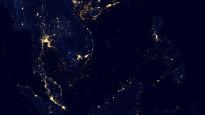
The US space agency, NASA, has officially launched a project to provide remote sensing data to Vietnam, Cambodia, and Laos, aiding regional environmental and population monitoring as part of a wider effort for sustainable resource management and planning in these countries.
More than 60 international scientists from these countries participated in NASA’s “International Science Team Meeting and Field Work” in collaboration with the University of Natural Sciences via Hanoi National University.
Rapid Land-Cover Land-Use Change (LCLUC) has occurred over Vietnam, Cambodia, and Laos, especially the loss of important forest regions, since the turn of the 21st century. The project aims to build a database to monitor the status and changing rate of land coverage and land use, in order to map changes to the population and demography in these countries.
The observations of LCLUS together with the LCLUC patterns, trends, and rate of change are coupled and integrated with the population and demographic data for each country. Accordingly, NASA allows scientists to use data from its remote sensing satellites to investigate and assess land use, change and impact in the area. Particularly, NASA’s Big Data source and the research and consultancy of the scientists participating in the project will be used for the research and training in the field of space science which is still young in Vietnam.
The project is expected to run for three years.
“The cooperation with NASA’s scientists will help local scientists learn more about modern space technology and remote sensing,” said Dr Pham Quang Tuan, associate professor and Head of the Faculty of Geography, University of Science, Hanoi National University. “It’s also an opportunity to access new technologies to solve problems in urban development management and land use issues in Vietnam.”
NASA has been developing a scientific cooperation program with Vietnam since 2016, according to Nghiem Van Son, a senior researcher from NASA’s Jet Propulsion Laboratory at the California Institute of Technology, and one of the project’s founders. “Accordingly, data retrieved from satellites helped show places with droughts, fire-prone areas, and volumetric flow rates in rivers so that scientists can have a comprehensive picture of Vietnam’s landmass and natural disaster risk management,” he explained.


