


By Yue Yuan
In this two-part study, exclusive to SpaceWatch.Global, researcher Yue Yuan examines the role of satellite technologies in detecting and monitoring the ongoing outbreak of the Coronavirus – also known as COVID-19 – and their wider role in national and global public health.
The outbreak of a fast-moving respiratory virus known as COVID-19 has infected tens of thousands of people in China during the busiest travel period of the year. During the battle against the vector-borne coronavirus, satellite technologies and space-based systems have played crucial roles in coordinating all sectors of society and controlling the spread of infectious diseases in China. Space services, including Mapping and Geographic Information Systems (GIS)-driven spatial health information infrastructure, remote sensing, telemedicine, satellite communication, Artificial Intelligence (AI)-driven satellites, and a global navigation satellite system, exert a critical function on approximately 70,000 patients’ diagnosis, screening, quarantine, and treatment, as well as rapid hospital construction and a wide-ranging disinfection operation. In the meantime, space applications have provided substantial contributions to nationwide online education, urgent transportation needs for essential goods between provinces, and the massive mobilization of health workers from across the country, among other things.
Facing the highly contagious nature of the coronavirus, it has been proven that the widespread use and improvement of space-based technologies enormously increase efficiency to help China fight the epidemic by reducing medically unnecessary face-to-face personal contact. In this context, the further popularization of space-based assets among countries and the promotion of closer international cooperation in using civil space science and technology could make a significant contribution to addressing global public health emergencies.
- Satellite-Based Positioning and Navigation Technology
A global navigation satellite system (GNSS) refers to a constellation of Earth-orbiting satellites providing signals from space that transmit positioning and timing data to its end-users that calculate ground positions by trilateration.[1] Within the COVID-19 control process, China employed its natively developed BeiDou Navigation Satellite System (BDS) to help control the disease. China began to send out its BeiDou-1 domestic navigation system in 2000 and completed the BeiDou-2 regional satellite navigation system for commercial use in 2012. Currently, China has successfully sent 28 BeiDou Phase III global navigation satellites into orbit, and the new global constellation is presumed to become operational in the first half of 2020.
From tracking patients’ accurate position to the monitoring of cargo transportation, as well as assigning GNSS-based navigation systems of autonomous drones for large-scale disinfection, the use of BeiDou satellites is already having a substantial impact on infection prevention.
Case 1: Positioning critically ill patients in Wuhan: Wuhan Mini Neighborhood APP
The ongoing epidemic situation in Wuhan, the capital city of Hubei Province and the epicenter of the coronavirus, is still immensely dangerous. In response, Wuhan has adopted a quarantine policy and lockdown measures to limit the mobility of the large number of infected persons. In order to ensure all patients are effectively treated, to reduce the risk of cross-infection between patients and the personnel involved in the delivery of treatment, and especially to find all severely ill patients who are left at home and cannot go to the hospital by themselves due to acute respiratory failure, the Wuhan government is promoting a BeiDou GNSS-based social app on WeChat (the messaging app with the greatest number of users in China), named Wuhan Mini Neighborhood, which presents an opportunity to extensively increase patient access and volume.
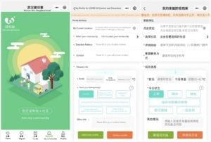
If Wuhan residents suspect that they have symptoms of the coronavirus, they are encouraged to report their current health conditions and body temperature by filling out the health profile form in the Mini Neighborhood app. After receiving the patient’s report, the application will immediately offer a preliminary online diagnosis and locate the patient’s exact address through the BeiDou positioning system. At the same time, community administrators and medical staff responsible for the patient’s community will come to check his or her physical health condition. If the person needs to be sent to the hospital for treatment, the community will arrange volunteers to transfer the patient to the designated hospital for infectious diseases by special ambulance designed for contagious diseases, notify neighbors to stay away from the address of the infected person, and decontaminate the source of infection.
Case 2: Unmanned aerial vehicle (UAV) for large-scale disinfection
To curb the high concentrations of virus and bacteria particles in the air, local governments; China’s leading drone manufacturers, such as DJI, XAG, and Qianxun Spatial Intelligence; and drone enthusiasts dispatched in total more than 10,000 disinfection drones to support various provinces afflicted by the coronavirus.
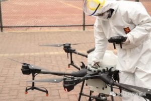
By implementing BeiDou’s high-precision navigation and positioning service, disinfection UAVs can automatically detect the area of bacteria and perform at centimeter-level accuracy, demonstrating strong mobility and high functional efficiency during the nationwide aerial disinfectant spraying. Before being used for the epidemic prevention team, most of the drones served as agricultural sprayers. By changing ammunition from pesticide to disinfectant fluid, the little aerial warriors swiftly shift their battlefield from farmland to densely populated city block, communities having confirmed or suspected cases of coronavirus, and rural villages with a weaker health system and inferior sanitation conditions.
Drone-based aerial biocontrol is proving to be a much more productive method of delivering public hygiene. With a capacity of 10 liters per load, the drone has the ability to spray an area of 5,000 square meters in 10 to 15 minutes. It is estimated that the disinfection operation has covered 600 million square meters across the country so far. The UAVs’ spraying efficiency can be 50 times faster than traditional means, while reducing risk to workers who would otherwise be dealing with biosafety hazards, exposure to either the high-level disinfecting chemicals or the infectious virus.
Case 3: HaiGe Smart Epidemic Prevention Management Platform for employees
As the coronavirus spreads rapidly across China, the HaiGe Smart Epidemic Prevention Management Platform, a BeiDou-based complex platform for health monitoring, is providing a solution to mitigate fears employees have about contracting the coronavirus during the commute to work.
With the support of the BeiDou system and with the assistance of the newly developed “Dolphin I” baseband chip and BeiDou III RX37 Series radio frequency chip, which are two high-precision navigation chips used to position at an 100Hz update rate with centimeter-level accuracy, the HaiGe Smart Epidemic Prevention Management Platform is providing hybrid outdoor and indoor location positioning services to capture the location history of infectious patients.
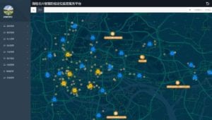
By connecting the database of the infected persons and regional info, and collecting news released by the Chinese Center for Disease Control and Prevention (CDC), the platform is capable of displaying the real-time cartography of infectious disease locations and identifying hotspots of disease with the use of a trajectory tracking algorithm. After comparing the location of the source of infection with the common route of employees’ daily commute, and analyzing the density of people and vehicles at different time periods, the system can automatically replan the travel route for users to avoid contagious areas.
Meanwhile, the platform continually publicizes epidemic-related news and advice in a timely and accurate manner to employees, enterprises, and the local government. In the event of an emergency, the system will issue an emergency alert and warning message reminder to the user’s mobile phone.
Case 4: GNSS-based vehicle networking control system and delivery robots
After announcing a state of emergency due to the outbreak of coronavirus, Wuhan and its surrounding regions enacted strict transportation restrictions on transit links out of the city and shut down all public bus and shuttle services inside the city. In order to ensure that Wuhan people have adequate medical supplies and daily necessities, cargo and logistics vehicles from other provinces across the country are continuously transporting medical equipment and prefabricated units for facilities, masks, agricultural and sideline products, fruit, and vegetables to Hubei Province.
As trans-provincial highway conditions change rapidly due to the daily temporary traffic control, drivers from other provinces sometimes have to deal with unnecessary detours and severe traffic congestion, causing the the loss of perishable goods and unbalanced distribution of urgent supplies in the end. GNSS-based vehicle networking system provides both regulators and drivers a convenient a way to bridge the information asymmetry on the road. Considering that satellite technology works in remote locations and allows for real-time communication with remote drivers, China’s transportation management department equipped all vehicles to Wuhan with BeiDou mobile satellite positioning devices with access to the national vehicle networking control system. By doing so, the transportation command center can monitor the operation status of vehicles on interprovincial highways and implement reasonable dispatch and management of the monitored vehicles, building an optimal allocation of public goods.
After goods arrive at Wuhan, GNSS technology will continue its indispensable function: indoor autonomous robots equipped with BeiDou terminals are on standby for the contactless delivery missions to distribute medical supplies, groceries, food, and medicines in the designated hospitals and local communities under quarantine.
Aside from accelerating the transportation process, the unmanned delivery robots help to minimize the risk of potential infections caused by unnecessary personal contact, and meet the urgent needs of both front-line medical staff and local residents. With the backing of automatic identification systems and the BeiDou navigation satellite system, delivery robots are loaded up with medical necessities and given instructions of where in the hospital or local community to go. They can automatically identify the destination and drop off the items. Meanwhile, satellite data also helps robots navigate around to pick up waste and ship it out of the quarantine zone based on a collision-free trajectory. During the distribution process, all the information and data of the robot will also be synchronized to the control center, so that staff can track and monitor the delivery records.
Visit SpaceWatch.Global tomorrow to read Part Two of this insightful article.

Yue Yuan is pursuing research on space security policy, China-US-Russia relations, nuclear arms control and disarmament, emerging technologies and international security. She worked with United Nations Institute for Disarmament Research’s space security department and the Center on Terrorism, Extremism, and Counterterrorism (CTEC) at Middlebury Institute. She holds a B.A. from the China Foreign Affairs University and a dual master’s degree in international affairs from the Moscow State Institute of International Relations (MGIMO) in Russia, and nonproliferation and terrorism studies from the Middlebury Institute of International Studies at Monterey in the U.S.